
Geonarratives
Geonarratives are web applications that combine interactive web maps with narrative text, images, and multimedia content.
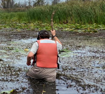
Phragmites Management and Variable Great Lakes Water Levels
Phragmites australis is a pervasive invasive species across North America and a particular problem in the Great Lakes basin. Land managers spend a great deal of time and resources controlling Phragmites basin-wide. Phragmites expansion across the basin has historically been heavily influenced by water levels. As water levels continue to fluctuate, managers may be able to exploit water levels to implement more effective management. Here, we aim to provide land managers, decision makers, and the public with a historical perspective on the influence of water levels on Phragmites expansion and to identify Phragmites populations best suited for management in high water.
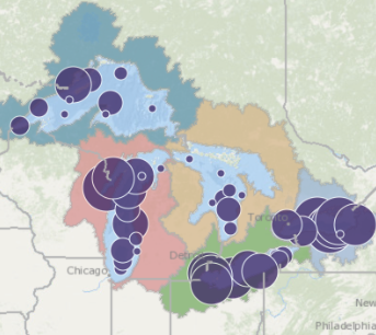
Great Lakes Mercury Sources Revealed
For the first time, resource managers in the Great Lakes can identify sources of mercury, a toxic chemical of significant concern in the region, thanks to a new "fingerprinting" tool for mercury developed by the U.S. Geological Survey (USGS) and collaborators at the University of Wisconsin-Madison. The mercury "fingerprint" is determined by measuring subtle differences in the type of individual mercury isotopes in environmental samples including sediment, biota, water, and air.
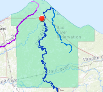
Measuring the July 2016 flood in northern Wisconsin and the Bad River Reservation
Immediately following the flood and continuing through September 2016, the U.S. Geological Survey (USGS) and the Bad River Band of the Lake Superior Tribe of Chippewa Indians (Bad River Tribe) began documenting the flood by collecting evidence of peak flood levels, called high-water marks. USGS scientists used these high-water marks, along with streamflow and lake level, to reconstruct the extent and depth of flood inundation around three streams: the Bad River, Beartrap Creek, and Denomie Creek.
You can view a longer list of USGS Geonarratives at the link below.
View More GeonarrativesWant to know more about Geonarratives?
For assistance with creating a USGS, National Park Service, or GeoPlatform VisID compliant geonarrative or hosting your page at geonarrative.usgs.gov, please contact WIM's hosting team at usgs-geonarrative-hosting@doimspp.onmicrosoft.com.
If you think you have a project that could benefit from a geonarrative, please don't hesitate to contact us with any questions or inquiries on our availability to assist.